Log in
All resources
Create a design
481 Free Artworks of Index Maps
maps in the library of congress
town maps by l. r. burleigh
l. r. burleigh
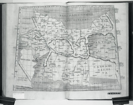
zehn karten und ansichten den schlachtfelden des amerikanischen unabhängigkeitskreiges in den staaten pennsylvanien und new york
drawing
digital library of university of wroclaw
shober & carqueville lithographing company
a map of the british empire in america with the french and spanish settlements adjacent thereto
bird's eye view maps of new york (state)
maps of paris from the david rumsey historical map collection
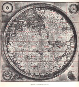
fra mauro map by sector
index maps
maps by matthäus seutter
latin-language maps
maps by willem and johannes blaeu
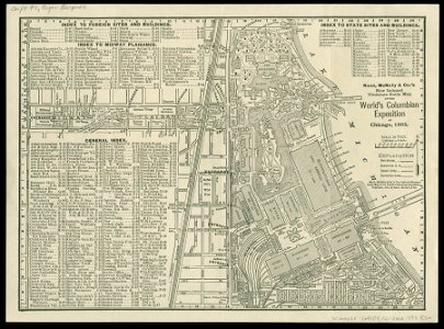
world's columbian exposition
newberry library
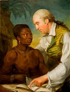
paintings of men with open books
paintings in nordiska museet
artist missing
london
maps in the library of congress
1885 maps of new york (state)
maps in the library of congress
1889 maps of new york (state)
maps by willem and johannes blaeu
maps of paris from the david rumsey historical map collection
maps of paris by caspar merian
maps by willem and johannes blaeu
maps by willem and johannes blaeu
maps in the staats- und universitätsbibliothek hamburg
daniel frese
maps of paris from the david rumsey historical map collection
proletarian literature
maps in the library of congress
1889 maps of new york (state)
maps in the library of congress
1884 maps of new york (state)
maps in the library of congress
1886 maps of new york (state)
maps in the library of congress
1877 maps of the united states
zehn karten und ansichten den schlachtfelden des amerikanischen unabhängigkeitskreiges in den staaten pennsylvanien und new york
maps in the library of congress
colonial history of the united states
old maps of new york (state)
maps in the library of congress
old maps of anniston, alabama
frank leslie's illustrated newspaper, 1876
maps in the library of congress
maps of paris in the 1790s
1797 maps
maps of paris from the university of wisconsin-milwaukee libraries
plan de roussel
petit atlas pittoresque des 48 quartiers de la ville de paris, david rumsey historical map collection
maps of paris from the david rumsey historical map collection
petit atlas pittoresque des 48 quartiers de la ville de paris, david rumsey historical map collection
maps of paris from the david rumsey historical map collection
zehn karten und ansichten den schlachtfelden des amerikanischen unabhängigkeitskreiges in den staaten pennsylvanien und new york
maps in the library of congress
maps in the library of congress
old maps of new hampshire
maps in the library of congress
1886 maps of vermont
maps in the library of congress
1889 maps of michigan
maps in the library of congress
1880 maps
maps in the library of congress
1886 maps of massachusetts
eran laor cartographic collection
cornelis de bruyn
eran laor cartographic collection
cornelis de bruyn
maps in the library of congress
1887 maps of massachusetts
shober & carqueville lithographing company
maps in the library of congress
18th-century maps of kent
maps by thomas kitchin
maps in the library of congress
1877 maps of the united states
civitates orbis terrarum. de praecipuis totius universi urbibus. liber secundus
maps of tunis and la goleta by braun & hogenberg
maps in the library of congress
1886 maps of massachusetts
maps in the library of congress
1877 maps of the united states
a map of the british empire in america with the french and spanish settlements adjacent thereto
maps in the library of congress
a map of the british empire in america with the french and spanish settlements adjacent thereto
maps in the library of congress
maps in the library of congress
1841 maps of massachusetts
maps in the library of congress
1885 maps of new york (state)
maps in the library of congress
1889 maps of new york (state)
maps in the library of congress
birds-eye view of seattle, 1884
maps in the library of congress
1875 maps of california
plan de la ville et faubourg de paris, divisé en ses 48 sections by mondhare & jean
maps of paris from the stanford libraries
maps in the library of congress
1785 maps
maps in the library of congress
1670 maps
a voyage to abyssinia, and travels into the interior of that country, executed under the orders of the british government in the years 1809 & 1810
john outhett
zehn karten und ansichten den schlachtfelden des amerikanischen unabhängigkeitskreiges in den staaten pennsylvanien und new york
maps in the library of congress
18th-century maps of new orleans
maps in the library of congress
maps of paris from the david rumsey historical map collection
map of paris by jouvin de rochefort (boutier 133)
plan de la ville et faubourg de paris, divisé en ses 48 sections by mondhare & jean
maps of paris from the stanford libraries
plan routier de la ville et faubourg de paris by jean lattré
maps of paris from the stanford libraries
maps in the library of congress
1877 maps of the united states
galleria delle carte geografiche - ceiling
august 2019 in rome
maps in the library of congress
1758 maps of cuba
maps by petrus schenk
1750s maps of saxony
a voyage to abyssinia, and travels into the interior of that country, executed under the orders of the british government in the years 1809 & 1810
john outhett
ancona (galleria delle carte geografiche)
18th-century maps of kent
maps by thomas kitchin
maps by jakob van der schley
old maps of southeast asia
a voyage to abyssinia, and travels into the interior of that country, executed under the orders of the british government in the years 1809 & 1810
john outhett
maps in the library of congress
1773 maps of the united states
zehn karten und ansichten den schlachtfelden des amerikanischen unabhängigkeitskreiges in den staaten pennsylvanien und new york
maps in the library of congress
zehn karten und ansichten den schlachtfelden des amerikanischen unabhängigkeitskreiges in den staaten pennsylvanien und new york
maps in the library of congress
atlas sive cosmographicae (gerardus mercator, 1596)
hendrik hondius the younger
civitates orbis terrarum. de praecipuis totius universi urbibus. liber secundus
maps of kleve by braun & hogenberg
civitates orbis terrarum. de praecipuis totius universi urbibus. liber secundus
maps of neuss by braun & hogenberg
civitates orbis terrarum. de praecipuis totius universi urbibus. liber secundus
maps of wissembourg by braun & hogenberg
a map of the british empire in america with the french and spanish settlements adjacent thereto
maps in the library of congress
maps in the library of congress
1900 maps of philadelphia
corsica in the 20th century
guido colucci
civitas vetus (galleria delle carte geografiche)
a map of the british empire in america with the french and spanish settlements adjacent thereto
maps in the library of congress
everett d. graff collection of western americana
george f. cram
a map of the british empire in america with the french and spanish settlements adjacent thereto
maps in the library of congress
civitates orbis terrarum. urbium praecipuarum totius mundi. liber quartus
maps of harlingen by braun & hogenberg
civitates orbis terrarum. urbium praecipuarum totius mundi. liber quartus
maps of malmö by braun & hogenberg
civitates orbis terrarum. urbium praecipuarum totius mundi. liber quartus
maps of sloten by braun & hogenberg
zehn karten und ansichten den schlachtfelden des amerikanischen unabhängigkeitskreiges in den staaten pennsylvanien und new york
maps in the library of congress
zehn karten und ansichten den schlachtfelden des amerikanischen unabhängigkeitskreiges in den staaten pennsylvanien und new york
maps in the library of congress
zehn karten und ansichten den schlachtfelden des amerikanischen unabhängigkeitskreiges in den staaten pennsylvanien und new york
maps in the library of congress
zehn karten und ansichten den schlachtfelden des amerikanischen unabhängigkeitskreiges in den staaten pennsylvanien und new york
maps in the library of congress
zehn karten und ansichten den schlachtfelden des amerikanischen unabhängigkeitskreiges in den staaten pennsylvanien und new york
maps in the library of congress
maps in the library of congress
civitates orbis terrarvm
maps in the british museum
taddeo crivelli
maps in the library of congress
1777 maps of new york (state)
a map of the british empire in america with the french and spanish settlements adjacent thereto
maps in the library of congress
a map of the british empire in america with the french and spanish settlements adjacent thereto
maps in the library of congress
old maps of amsterdam
hendrik de leth
a map of the british empire in america with the french and spanish settlements adjacent thereto
maps in the library of congress
atlas topographique des environs de paris (1780)
old index maps of europe
old maps of łódź
kosmopolita
civitates orbis terrarum. urbium praecipuarum totius mundi. liber quartus
maps of lund by braun & hogenberg
civitates orbis terrarum. urbium praecipuarum totius mundi. liber quartus
maps of malmö by braun & hogenberg
a & c black general atlas of the world
1850s maps of the world
1 - 100 of 481
Next page
/ 5


![[Ten maps and views of the battlefields of the American Revolutionary War in the states of Pennsylvania and New York], 1777](https://cdn.creazilla.com/illustrations/10001017178/ten-maps-and-views-of-the-battlefields-of-the-american-revolutionary-war-in-the-states-of-pennsylvania-and-new-york-1777-md.jpg)


![[Ten maps and views of the battlefields of the American Revolutionary War in the states of Pennsylvania and New York], 1777](https://cdn.creazilla.com/illustrations/10001017179/ten-maps-and-views-of-the-battlefields-of-the-american-revolutionary-war-in-the-states-of-pennsylvania-and-new-york-1777-md.jpg)


![Panoramic view of the city of Red Wing, Goddhue [sic] Co., Minnesota, 1880](https://cdn.creazilla.com/illustrations/10001270748/panoramic-view-of-the-city-of-red-wing-goddhue-sic-co-minnesota-1880-md.jpg)


![Manatvs located on the Noot [sic] Riuier., 1639](https://cdn.creazilla.com/illustrations/10001304673/manatvs-located-on-the-noot-sic-riuier-1639-md.jpg)

![[Ten maps and views of the battlefields of the American Revolutionary War in the states of Pennsylvania and New York], 1777](https://cdn.creazilla.com/illustrations/10001550825/ten-maps-and-views-of-the-battlefields-of-the-american-revolutionary-war-in-the-states-of-pennsylvania-and-new-york-1777-md.jpg)


![[Ten maps and views of the battlefields of the American Revolutionary War in the states of Pennsylvania and New York], 1777](https://cdn.creazilla.com/illustrations/10000484458/ten-maps-and-views-of-the-battlefields-of-the-american-revolutionary-war-in-the-states-of-pennsylvania-and-new-york-1777-md.jpg)
![[Ten maps and views of the battlefields of the American Revolutionary War in the states of Pennsylvania and New York], 1777](https://cdn.creazilla.com/illustrations/10001455242/ten-maps-and-views-of-the-battlefields-of-the-american-revolutionary-war-in-the-states-of-pennsylvania-and-new-york-1777-md.jpg)


![[Ten maps and views of the battlefields of the American Revolutionary War in the states of Pennsylvania and New York], 1777](https://cdn.creazilla.com/illustrations/10000506393/ten-maps-and-views-of-the-battlefields-of-the-american-revolutionary-war-in-the-states-of-pennsylvania-and-new-york-1777-md.jpg)
![[Ten maps and views of the battlefields of the American Revolutionary War in the states of Pennsylvania and New York], 1777](https://cdn.creazilla.com/illustrations/10000597684/ten-maps-and-views-of-the-battlefields-of-the-american-revolutionary-war-in-the-states-of-pennsylvania-and-new-york-1777-md.jpg)
![[Ten maps and views of the battlefields of the American Revolutionary War in the states of Pennsylvania and New York], 1777](https://cdn.creazilla.com/illustrations/10001450663/ten-maps-and-views-of-the-battlefields-of-the-american-revolutionary-war-in-the-states-of-pennsylvania-and-new-york-1777-md.jpg)
![[Ten maps and views of the battlefields of the American Revolutionary War in the states of Pennsylvania and New York], 1777](https://cdn.creazilla.com/illustrations/10000887733/ten-maps-and-views-of-the-battlefields-of-the-american-revolutionary-war-in-the-states-of-pennsylvania-and-new-york-1777-md.jpg)
![[Ten maps and views of the battlefields of the American Revolutionary War in the states of Pennsylvania and New York], 1777](https://cdn.creazilla.com/illustrations/10001122410/ten-maps-and-views-of-the-battlefields-of-the-american-revolutionary-war-in-the-states-of-pennsylvania-and-new-york-1777-md.jpg)